Skip to content
  • Home
  • Boating
    • Safety
      • Cautions
      • Crossing Bars
    • Webcams
    • Waves, Tides & Weather
    • Navigation Information
    • Waterways Online
    • Boating Guides
    • Boating Facilities
  • Ports & Waterways
    • Port Management
      • Port of Anderson Inlet
      • Port of Corner Inlet & Port Albert
      • Port of Gippsland Lakes
      • Port of Mallacoota Inlet
      • Port of Snowy River (Marlo)
      • Lake Tyers
      • Shallow Inlet
      • Tamboon Inlet
      • Sydenham Inlet
    • Sand Management
    • Environment
    • Current & Planned Works
    • Permits & Authorities
  • Notices & Alerts
    • Notice to Mariners & Warnings
    • Media Releases & Local News
  • Services
    • Commercial Shipping
    • Commercial Services
    • Berths & Moorings
    • Online Site Induction
  • Publications
    • Plans
    • Bathymetric Surveys
    • Reports
    • Harbour Masters Directions
  • About
    • Our Board
    • Management Structure
    • Employment
    • Tenders
  • Contact
    • Emergency Information
    • Report an Incident
    • Feedback and Enquiries
Facebook-square
Close

Tamboon Inlet

Tamboon Inlet is on the south-east coast of Victoria, located south of the township of Cann River, and is approximately 467kms (6 hours travel time) via the Princess Highway from the Melbourne CBD.

Tamboon Inlet is a small waterway which is generally closed to Bass Strait, although on occasions is opened by prevailing weather and water levels or artificial opening by the Catchment Management Authority to prevent flooding of built assets. The Inlet is a popular tourist destination for holiday makers and anglers alike. Most of the Inlet and extending arms are navigable by small recreational vessels only.

Navigational Information

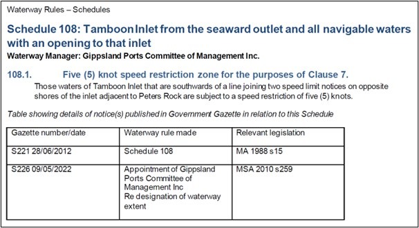
VOZR (Vessel Operating and Zoning Rules) Schedule 108 Tamboon Inlet

View other Ports & Waterways

The areas managed by Gippsland Ports consist of five designated Local Ports and four waterways.

  • Anderson Inlet
  • Corner Inlet & Port Albert
  • Gippsland Lakes
  • Mallacoota
  • Snowy River (Marlo)
  • Lake Tyers
  • Shallow Inlet
  • Tamboon Inlet
  • Sydenham Inlet

More Information

If you're looking for further information about certain topics, select one below & scroll down to read more about it.

Cautions
Boating Facilities

Cautions

Go to NTM’s (for this waterway)

Navigational aids within the Gippsland Regional Ports conform to the International Association of Lighthouse Authorities (IALA) Buoyage System “A”. Starboard-hand (or right side) marks are green, whilst Port-Hand (or left side) marks are red. Cardinal marks are yellow and black; Special marks are yellow and Isolated Danger marks black and red.

In using the system it is essential to remember that the direction of buoyage is taken from the seaward entrance of these ports. When returning towards the entrance the situation would be reversed.

Go to Waterways Online
Go to bathymetric surveys

Boating Facilities

Facilities managed by Gippsland Ports:

All navigation aids and zoning signs/buoys

Facilities managed by other authorities:

DELWP

Furnell Landing Boat ramp and carpark
Peach Tree boat ramp

Parks Victoria

Peach Tree camping area
Tamboon Inlet Remote campsites (North, East and South)

Quick Links

Hover over a topic to view more available links & information.

Subscribe

Boating

Ports & Waterways

Notices & Alerts

Commercial Services

Publications

About

Boating

Overview
Safety
Webcams
Waves, Tides & Weather
Navigation Information
Waterways Online
Boating Guides
Boating Facilities

Ports & Waterways

Overview
Port Management
Sand Management
Ports & Waterways
Environment
Current & Planned Works
Permits & Authorities

Notices & Alerts

Overview
Notice to Mariners & Warnings
Media Releases & Local News

Commercial Services

Overview
Commercial Shipping
Commercial Fee for Service
Berths & Moorings
Online Site Induction

Publications

Overview
Plans
Bathymetric Surveys
Reports

About

Overview
Our Board
Management Structure
Employment
Tenders

Gippsland Ports is a Committee of Management established in 1996 to manage the State Government™ Ports and Harbours functions for the five designated local ports of Gippsland.

Head Office

  • 97 Main Street, PO Box 388, Bairnsdale, VIC 3875
  • (03) 5150 0500
  • (03) 5150 0501
  • feedback@gippslandports.vic.gov.au

Lakes Entrance Office & Depot

  • Bullock Island, Lakes Entrance, VIC 3909
  • (03) 5155 6900
  • (03) 5155 6901

Bullock Island Boatyard

  • (03) 5155 6950

Paynesville Boatyard

  • Slip Road, Paynesville, VIC 3880
  • (03) 5156 6352
  • (03) 5156 6816

Port Welshpool

  • 84 Lewis Street, Port Welshpool, VIC 3965
  • (03) 5688 1303
  • (03) 5688 1658

Copyright All Rights Reserved © 2024

  • Privacy Policy
Website by Small Dog Design

Subscribe

Subscribe to receive regular email updates

Loading