

Tide predictions for waterways and coastal areas adjacent to Gippsland Ports’ areas of responsibility are published by the Bureau of Meteorology.
The ‘real time’ tide table and weather information is an initiative of Gippsland Ports that will assist waterways users to check prevailing conditions at the Entrance and bar at Lakes Entrance and the boat harbour at Port Welshpool.
Lakes Entrance
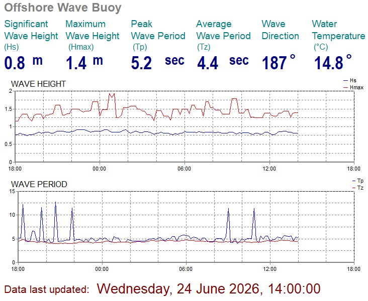
A Directional Waverider Buoy is installed at a location offshore from Lakes Entrance to measure wave height, period, direction, and surface water temperature. Mariners should note that this buoy is located at an approximate position of S 37° 54.9075′ E 147° 57.9379′ (WGS 84). A long elastic mooring system has been utilized to secure the buoy and consequently the position of the buoy may vary with tide and currents. Mariners are directed to navigate with caution when transiting the area and to remain at least 200m clear of the buoy. No vessel is to moor to the buoy at any time. The buoy displays the following light characteristic: Fl(5)Y.
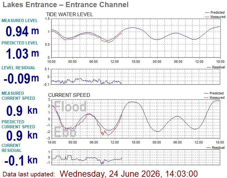
Tide measuring equipment is installed to provide near-real time tide data. Tide gauges at Lakes Entrance are located in the Entrance Channel midway along the training walls, and at the Gippsland Ports depot jetty on Bullock Island.
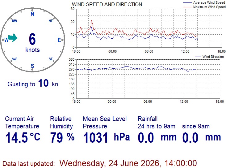
An Automatic Weather Station is installed to provide measurements of air pressure, air temperature, wind speed and direction, relative humidity and rainfall.
Waves
Read More
This page contains wave observations from a moored Waverider buoy located approximately 1.5 nm SE of Lakes Entrance, Victoria in 23 metres depth. Position: 37° 54.908′S, 147° 57.938′E (WGS84).
- This data is automatically generated and is not quality controlled.
- All times and dates are in Victorian local time.
- Each ‘observation’ (or record) is obtained by sampling the waves for 27 minutes.
- This page is automatically updated every 10 minutes from available data.
| Key | |||
|---|---|---|---|
|
Hs |
Height of significant wave (metres). This is the average height of the highest one third of the waves in the record. |
||
|
Hmax |
Maximum height of the waves (metres) in the record. |
||
|
Tz |
Average time (seconds) between all waves in the record. |
||
|
Tp |
The peak energy period (seconds) is the period of the dominant waves in the record. |
||
|
Direction |
The direction from which waves are coming (degrees True) at the peak energy period (Tp). |
||
Tides
Read More
This page contains water level and current observations from sensors located in the entrance channel at Lakes Entrance, Victoria. Location is approximately 150 metres NW of the entrance breakwater. Position: 37º 53.4’ S, 147º 58.4’ E (WGS84).
- The data is automatically generated and is not quality controlled.
- All times and dates are in Victorian local time.
- Each ‘observation’ (or record) is obtained by sampling water levels and currents at 6 minute intervals.
- This page is automatically updated every 6 minutes from available data.
| Key | |||
|---|---|---|---|
|
Measured Level |
The measured water level at the sensor (metres) above Chart Datum. |
||
|
Predicted Level |
The predicted tidal water level at the sensor (metres) above Chart Datum. |
||
|
Level Residual |
The measured level minus the predicted tidal level (metres). This value is positive when the measured level is higher than the predicted level. |
||
|
Measured Current Speed |
The measured current speed (knots) near the current sensor. An Ebb flow denotes water moving towards the SE. A Flood flow denotes water moving towards the NW. |
||
|
Predicted Current Speed |
The predicted tidal current speed (knots) near the current sensor. |
||
|
Current Residual |
The measured current speed minus the predicted tidal current speed (knots). This value is positive when the measured speed is greater than the predicted tidal speed. |
||
Weather
Read More
This page contains wind observations from a sensor located at the southern end of the Eastern Breakwater at Lakes Entrance, Victoria. Position: 37º 53.4’ S, 147º 58.4’ E (WGS84).
The weather observations are from sensors located at Bullock Island at Lakes Entrance, Victoria. Position: 37º 53.0’ S, 147º 58.3’ E (WGS84).
- This data is automatically generated and is not quality controlled.
- All times and dates are in Victorian local time.
- Each ‘observation’ (or record) is obtained by sampling the water levels and currents 10 minutes.
- This page is automatically updated every 10 minutes from available data.
| Key | |||
|---|---|---|---|
|
Average Wind Speed & Direction |
This is the average over 10 minutes of data. Speed is in knots. The Direction is the direction the wind is coming from (degrees True). |
||
|
Gust Wind Speed & Direction |
This is the highest speed sustained for 2 seconds during the 10 minute record. Speed is in knots. The Direction is the direction the wind is coming from (degrees True). |
||
Disclaimer: Users of this information accept all risks and responsibility for losses, damages, costs and other consequences resulting directly or indirectly from using this site and any information or material available from it. To the maximum permitted by law, Gippsland Ports excludes all liability to any person arising directly or indirectly from using this site and any information or material available from it.
This product is based on Bureau of Meteorology information that has subsequently been modified. The Bureau does not necessarily support or endorse, or have any connection with, the product. In respect of that part of the information which is sourced from the Bureau, and to the maximum extent permitted by law. The Bureau makes no representation and gives no warranty of any kind whether express, implied, statutory or otherwise in respect to the availability, accuracy, currency, completeness, quality or reliability of the information or that the information will be fit for any particular purpose or will not infringe any third party Intellectual Property rights; and the Bureau’s liability for any loss, damage, cost or expense resulting from use of, or reliance on, the information is entirely excluded.
Port Welshpool
Tide measuring equipment is installed to provide near-real time tide data. The tide gauge at Port Welshpool is located on the Port Welshpool Marginal Wharf. Waves and Weather information is not currently installed at Port Welshpool. It is recommended that mariners use this information in conjunction with the Victorian Tide Tables.
Tides
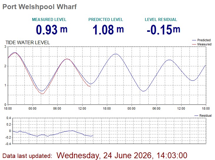
Read More
- This data are automatically generated and are not quality controlled.
- All times and dates are in Victorian local time.
- Each ‘observation’ (or record) is obtained by sampling the water levels and currents 10 minutes.
- This page is automatically updated every 10 minutes from available data.
| Key | |||
|---|---|---|---|
|
Measured Level |
The measured water level at the sensor (metres) above Chart Datum. |
||
|
Predicted Level |
The predicted tidal water level at the sensor (metres) above Chart Datum. |
||
|
Level Residual |
The measured level minus the predicted tidal level (metres). This value is positive when the measured level is higher than the predicted level. |
||
Disclaimer: Users of this information accept all risks and responsibility for losses, damages, costs and other consequences resulting directly or indirectly from using this site and any information or material available from it. To the maximum permitted by law, Gippsland Ports excludes all liability to any person arising directly or indirectly from using this site and any information or material available from it.
This product is based on Bureau of Meteorology information that has subsequently been modified. The Bureau does not necessarily support or endorse, or have any connection with, the product. In respect of that part of the information which is sourced from the Bureau, and to the maximum extent permitted by law. The Bureau makes no representation and gives no warranty of any kind whether express, implied, statutory or otherwise in respect to the availability, accuracy, currency, completeness, quality or reliability of the information or that the information will be fit for any particular purpose or will not infringe any third party Intellectual Property rights; and the Bureau’s liability for any loss, damage, cost or expense resulting from use of, or reliance on, the information is entirely excluded.
Current Predictions
Current predictions for the Entrance Channel at Lakes Entrance are available via the Lakes Entrance Tide & Current Predictions Dashboard. Vessel operators are advised that actual current speeds and directions may deviate substantially from predicted values due to a range of environmental influences, including wind conditions, atmospheric pressure variations, and rainfall within the catchment area.
Tide Predictions
Tide predictions for Lakes Entrance and Port Welshpool can be accessed through the below Dashboards:-
Alternatively, tide information is also available on the Bureau of Meteorology Website.
The following table shows average differences in time of high and low water for other locations relative to Lakes Entrance and Port Welshpool and also show the average rise of tide above datum prepared from available information.
| Name of Place | Time Difference | Rise of Tide | |
|---|---|---|---|
|
|
(Earlier) / Later |
Spring |
Neaps |
|
|
Hours / Mins |
Metres |
Metres |
|
Gabo Island |
(0 / 43) |
1.1 |
0.1 |
|
Eden (NSW) |
(0 / 34) |
1.8 |
0.2 |
|
Point Hicks |
(0 / 27) |
1.3 |
0.3 |
|
Lakes Entrance (Outer) |
(0 / 00) |
1.1 |
0.7 |
Predictions datum used is 11.367m below Colquhoun PM201 and 0.757m below Australian Height Datum (AHD).
Time variations have been obtained from the Australian National Tide Variations for Eden. Additional variations for East Gippsland and the Lakes will be sought and published in the future.
| Name of Place | Time Difference | Rise of Tide | |
|---|---|---|---|
|
|
(Earlier) / Later |
Spring |
Neaps |
|
|
Hours / Mins |
Metres |
Metres |
|
Port Welshpool (Rabbit Island) |
(1 / 20) |
2.4 |
2.1 |
|
Franklin Spit Light |
(0 / 40) |
2.4 |
1.9 |
|
Fishermans Wharf (Franklin River) |
(0 / 36) |
2.7 |
2.0 |
|
Bennison Channel |
(0 / 30) |
2.4 |
2.0 |
|
Port Albert Front Lead |
(0 / 30) |
2.1 |
1.6 |
|
No. 3 Franklin Channel Light |
(0 / 20) |
2.5 |
2.0 |
|
No. 2 Lewis Channel Light |
(0 / 20) |
2.4 |
1.9 |
|
Port Albert Pier |
(0 / 00) |
2.1 |
1.6 |
|
Port Welshpool Pier |
(0 / 00) |
2.6 |
1.7 |
Datum used is chart datum which is 3.511m below a Permanent Mark (Welshpool PM 47) and is I.509m below Australian Height Datum (AHD).
Disclaimer: This product is based on Bureau of Meteorology information that has subsequently been modified. The Bureau does not necessarily support or endorse, or have any connection with, the product. In respect of that part of the information which is sourced from the Bureau, and to the maximum extent permitted by law. The Bureau makes no representation and gives no warranty of any kind whether express, implied, statutory or otherwise in respect to the availability, accuracy, currency, completeness, quality or reliability of the information or that the information will be fit for any particular purpose or will not infringe any third party Intellectual Property rights; and the Bureau’s liability for any loss, damage, cost or expense resulting from use of, or reliance on, the information is entirely excluded.